


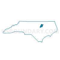
Voting District 0005, Nash County, North Carolina
About
Outline

Summary
| Unique Area Identifier | 640944 |
| Name | Voting District 0005 |
| County | Nash County |
| State | North Carolina |
| Area (square miles) | 31.71 |
| Land Area (square miles) | 31.66 |
| Water Area (square miles) | 0.04 |
| % of Land Area | 99.86 |
| % of Water Area | 0.14 |
| Latitude of the Internal Point | 35.79194440 |
| Longtitude of the Internal Point | -78.20573990 |
Maps


Graphs
Select a template below for downloading or customizing gragh for Voting District 0005, Nash County, North Carolina


Neighbors
Neighoring Voting District (by Name) Neighboring Voting District on the Map
- Voting District 0001, Nash County, NC
- Voting District 0006, Nash County, NC
- Voting District 09-03, Wake County, NC
- Voting District 13, Franklin County, NC
- Voting District PR20, Johnston County, NC
- Voting District PROL, Wilson County, NC
Top 10 Neighboring County Subdivision (by Population) Neighboring County Subdivision on the Map
- Little River township, Wake County, NC (12,528)
- O'Neals township, Johnston County, NC (8,868)
- Dunn township, Franklin County, NC (8,402)
- Old Fields township, Wilson County, NC (5,379)
- Bailey township, Nash County, NC (4,397)
- Dry Wells township, Nash County, NC (3,702)
- Ferrells township, Nash County, NC (2,946)
Top 10 Neighboring Place (by Population) Neighboring Place on the Map
Top 10 Neighboring Unified School District (by Population) Neighboring Unified School District on the Map
- Wake County Schools, NC (900,993)
- Johnston County Schools, NC (168,878)
- Nash-Rocky Mount Schools, NC (106,786)
- Wilson County Schools, NC (81,234)
- Franklin County Schools, NC (60,619)
Top 10 Neighboring State Legislative District Lower Chamber (by Population) Neighboring State Legislative District Lower Chamber on the Map
- State House District 39, NC (104,910)
- State House District 26, NC (95,937)
- State House District 49, NC (77,779)
- State House District 23, NC (75,657)
- State House District 25, NC (73,935)
Top 10 Neighboring State Legislative District Upper Chamber (by Population) Neighboring State Legislative District Upper Chamber on the Map
- State Senate District 14, NC (232,514)
- State Senate District 12, NC (210,500)
- State Senate District 7, NC (186,929)
- State Senate District 11, NC (177,074)
Top 10 Neighboring 111th Congressional District (by Population) Neighboring 111th Congressional District on the Map
- Congressional District 13, NC (753,104)
- Congressional District 2, NC (741,576)
- Congressional District 3, NC (735,979)
Top 10 Neighboring Census Tract (by Population) Neighboring Census Tract on the Map
- Census Tract 115, Nash County, NC (6,939)
- Census Tract 543.02, Wake County, NC (6,564)
- Census Tract 402.01, Johnston County, NC (6,342)
- Census Tract 15, Wilson County, NC (5,495)
- Census Tract 608.02, Franklin County, NC (4,954)
- Census Tract 114, Nash County, NC (4,304)